AlpineQuest Explorer Lite
- Travel & Local
- 2.3.8d
- 8.0 MB
- by Psyberia
- Android 2.1+
- Jan 12,2025
- Package Name: psyberia.alpinequest.free
Turn your phone into a powerful offline GPS using topographic maps!
No ads, data sharing, monetization, analytics, or third-party libraries.
AlpineQuest is the ultimate outdoor companion for hiking, running, trailblazing, hunting, sailing, geocaching, off-road navigation, and more.
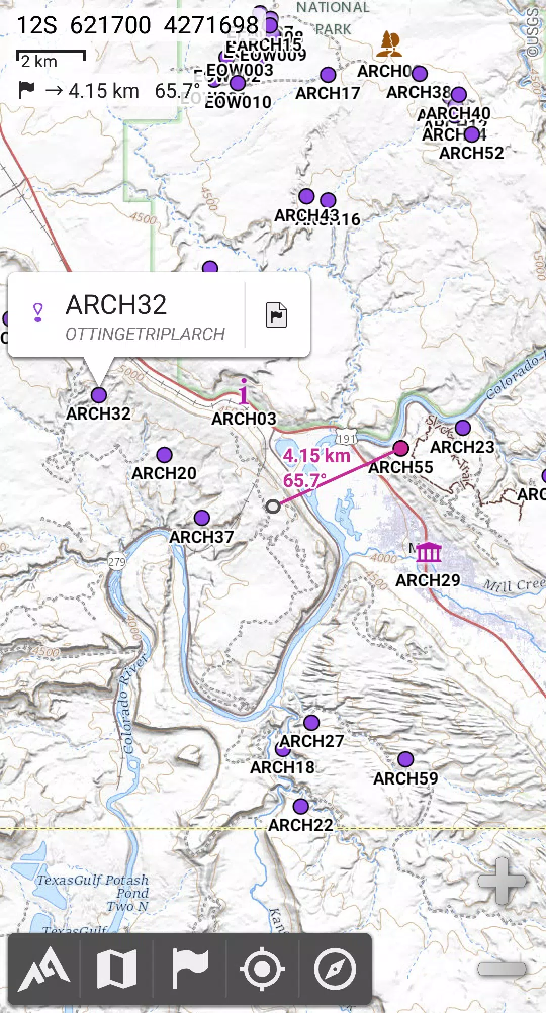
Access and store a vast range of online topographic maps for offline use, even without cell service. It also supports numerous onboard raster map formats.
With real-time GPS and compass functionality, getting lost is a thing of the past. Your location is displayed on the map, which can be oriented to match your view.
Create and share unlimited placemarks, track your routes, and access advanced statistics and interactive graphics. Unleash your exploration potential.
AlpineQuest's offline capabilities make it ideal for wilderness adventures, ensuring you stay on course even in remote areas.
Download the free Lite version today!
For suggestions or issues, please use our dedicated forum: https://www.alpinequest.net/forum (no registration required, all questions answered). Do not post in the comments section.
Key features (full version):
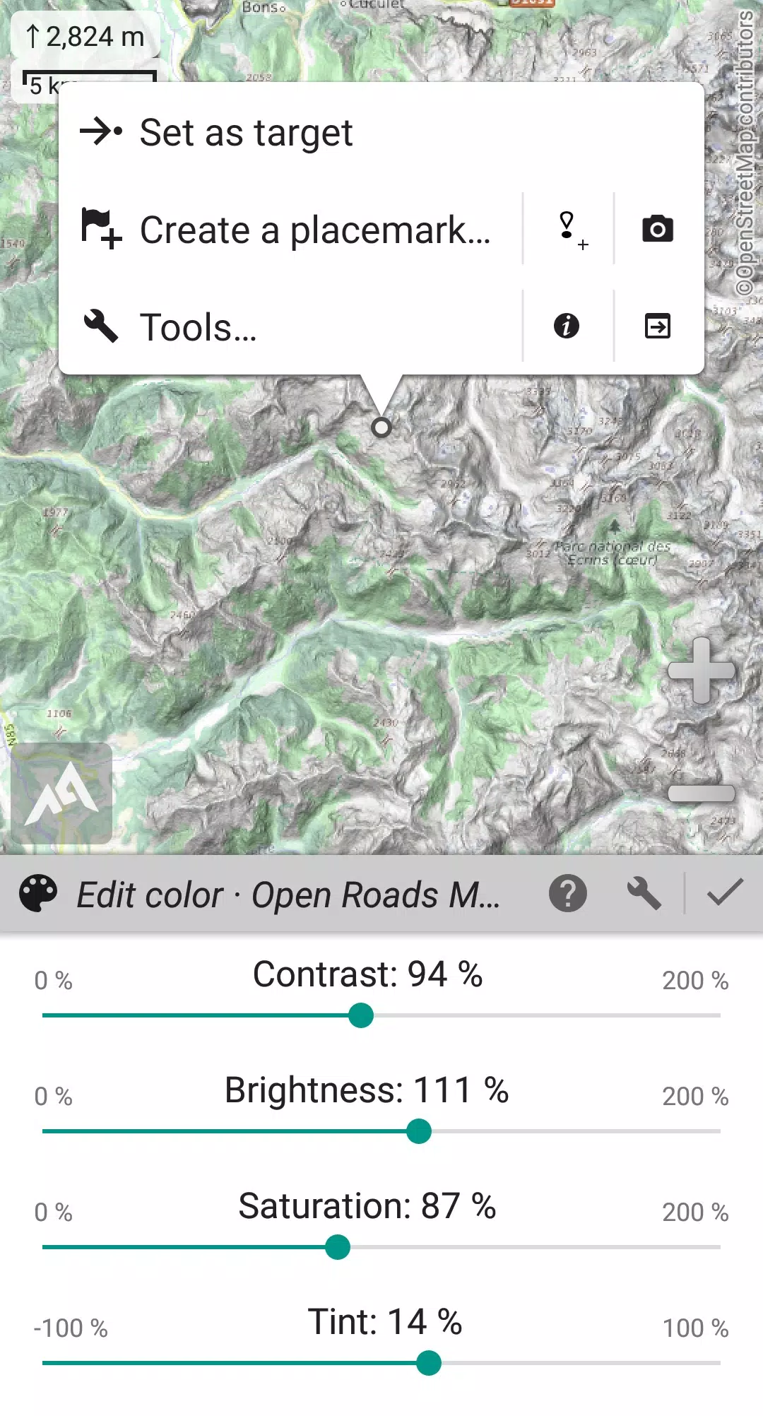
★★ Mapping ★★
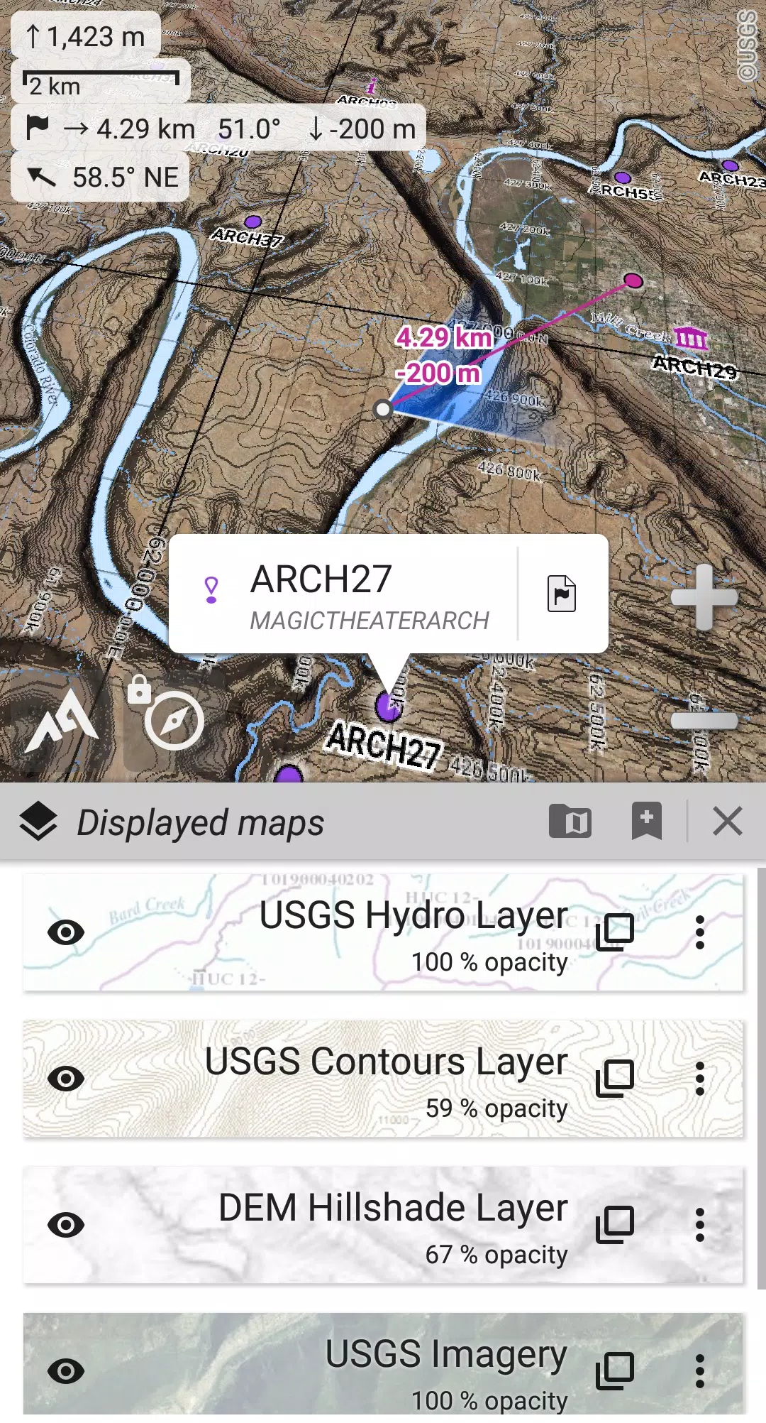
- Built-in online maps (with automatic local storage; road, topo, and satellite maps included) and online layers (road names, hillshade, contours).
- Easily add more online maps and layers from the community maps list (global and local topo maps).
- Complete area storage of online maps for offline use.
- Offline map support (raster) including KMZ Overlays, OziExplorer OZFx2, OZFx3 (partially), calibrated images, GeoTiff, GeoPackage GeoPkg, MbTile, SqliteDB, and TMS zipped tiles (use MOBAC, the free map creator, available on our website).
- QuickChart Memory Map support (.qct maps only, .qc3 maps incompatible).
- Built-in image calibration tool for using any scan or picture as a map.
- Digital elevation model (DEM) onboard storage (1-arcsec SRTM DEM) and support for HGT elevation files (1-arcsec and 3-arcsec resolutions) for terrain, hillshade, and steep slope displays.
- Polar map (Arctic and Antarctic) support.
- Multi-layer map display with per-map opacity, contrast, color, tint, and blending controls.
★★ Placemarks & Tracking ★★
- Create, save, and manage unlimited waypoints, routes, areas, and tracks.
- Import/export GPX, Google Earth KML/KMZ, and CSV/TSV files.
- Import ShapeFile SHP/PRJ/DBF, OziExplorer WPT/PLT, GeoJSON, IGC tracks, Geocaching LOC waypoints, and export AutoCAD DXF files.
- Share online locations with Community Placemarks.
- Detailed information, advanced statistics, and interactive graphics for all items.
- Time Controller for replaying time-tagged tracks.
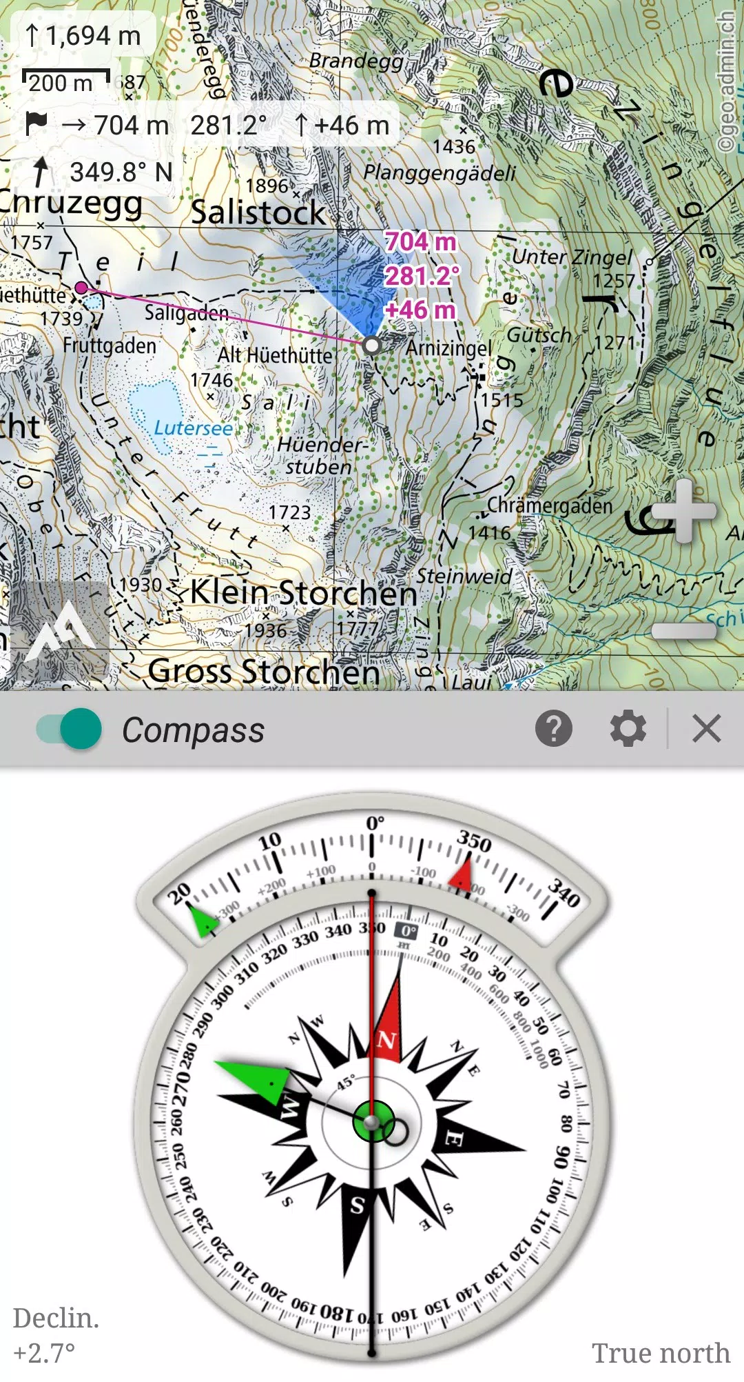
★★ GNSS & Orientation ★★
- On-map geolocation using device GNSS (GPS/Glonass/Galileo/…) or network.
- Map orientation, compass, and target finder.
- Built-in GNSS/Barometric track recorder (long tracking, separate lightweight process) with battery level and network strength recording.
- Proximity and off-route alerts.
- Barometer support (compatible devices).
★★ Additional Features ★★
- Metric, imperial, nautical, and hybrid distance units.
- Latitude/Longitude and grid coordinate formats (WGS, UTM, MGRS, USNG, OSGB, SK42, Lambert, QTH, …) with on-map grid display.
- Import hundreds of coordinate formats from https://www.spatialreference.org.
- And more…
What's New in Version 2.3.8d (Aug 14, 2024)
- Customizable menu bar style and position.
- Improved Android compatibility.
- Enhanced backup and restore tools.
- New default URL for sharing coordinates.
- Ability to set the application's "Media" folder as the default for placemarks, icons, pictures, and maps.
- Added Croatian and Persian translations.
- Various improvements and bug fixes.
Application GPS hors ligne correcte, mais manque de certaines fonctionnalités.
Super Offline-GPS App! Funktioniert einwandfrei ohne Internetverbindung. Sehr empfehlenswert für Wanderer und Outdoor-Fans!
Excellent offline GPS app! Works perfectly without needing an internet connection. Highly recommended for hikers and outdoor enthusiasts.
离线GPS应用不错,功能强大,使用方便。
Aplicación GPS offline muy útil. Funciona bien y es fácil de usar. Recomendada para actividades al aire libre.


-
 Gang Warfare Erupts in Prison Game Launch
A new mobile title, Prison Gang Wars, is now available for Android and iOS. Published by Black Halo Games, the name itself sets the stage for the experience. The developers were likely inspired by GTA during its creation. For the full scoop, read on.
Jun 03,2026 -
 Point-and-Click Comedy Corporate Thriller The Biggleboss Incident Is Now Out on Android
BUNKWORKS has released its debut title for Android: The Biggleboss Incident, which previously arrived on Steam and iOS earlier this year. This narrative-driven point-and-click adventure unfolds within the confines of corporate life.A Humorous Yet Bri
Jun 02,2026 - ◇ MultiVersus Shuts Down, Players Mourn Beloved Game Jun 01,2026
- ◇ Alien Isolation Beginner's Guide – Survive the Xenomorph Horror Jun 01,2026
- ◇ Master Penguin GO! With 10 Expert Strategies May 30,2026
- ◇ Pokemon Sleep Update Boosts Appearance Rates, Candy Gains May 30,2026
- ◇ Undecember launches massive overhaul alongside 4th anniversary festivities May 28,2026
- ◇ Terra Nil Heatwave Update Adds Three New Maps May 28,2026
- ◇ Seven Knights ReBIRTH Equipment & Accessories Guide — Gear Up Your Heroes Smartly May 22,2026
- ◇ Clash Royale Returns with Retro Royale Mode May 20,2026
- ◇ "DELTARUNE Chapter 5 Launches in 2026" May 20,2026
- ◇ Pre-Order Skyrim Dragonborn Helmet Now at IGN Store May 20,2026

![Roblox Forsaken Characters Tier List [UPDATED] (2025)](https://img.actcv.com/uploads/18/17380116246797f3e8a8a39.jpg)


- 1 Silent Hill 2 Remake Confirms Xbox, Switch Release in 2025 Feb 08,2025
- 2 Fix 'Can't Connect to Host' Error in Ready or Not: Quick Solutions Jun 13,2025
- 3 The Best Free Comic Book Sites and Apps in 2025 Mar 18,2025
- 4 Dragon Soul Tier List: Ultimate Guide May 12,2025
- 5 Connect Asus ROG Ally to TV or Monitor: Easy Guide Apr 06,2025
- 6 "Persona Games and Spin-Offs: Complete Chronological List" Apr 09,2025
- 7 Assassin's Creed Shadows: Max Level and Rank Cap Revealed Mar 27,2025
- 8 How to Run JioHotstar on PC with BlueStacks Feb 28,2025


-
Top Arcade Classics and New Hits
A total of 10
-
Addictive Arcade Games for Mobile
A total of 10
-
Android Apps for Video Content Creation
A total of 10