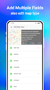
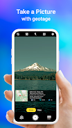
GPS Map Camera App
- Photography
- v1.1.6
- 5.00M
- Android 5.1 or later
- Mar 03,2025
- Package Name: com.locationonphoto.gpsmapcamera.geotagging.gpscam
This GPS Map Camera app merges camera functionality with GPS location tracking, enabling users to visually document their journeys. Key features include geotagging, GPS scanning, and GPS mapping, allowing for the creation of photo maps displaying photos based on their location. The app also supports adding GPS location data to pre-existing photos. Its intuitive design ensures seamless operation on GPS-enabled devices.
The GPS Map Camera App boasts six key advantages:
-
Integrated Camera and GPS: Capture photos instantly geotagged with precise location data, creating a visual travelogue.
-
Versatile Photo Capture and Tracking: Use the integrated GPS camera or add geotagging to existing photos.
-
Comprehensive Mapping: Easily view photos on a GPS map, visualizing their locations along a route.
-
Customizable Date/Time Stamps: Add date and time stamps to photos in your preferred format.
-
Customizable Photo Management: Save photos with custom names and utilize live navigation for effortless organization.
-
Lightweight Alternative: A Lite version provides many core features while minimizing device storage usage.


-
 Gang Warfare Erupts in Prison Game Launch
A new mobile title, Prison Gang Wars, is now available for Android and iOS. Published by Black Halo Games, the name itself sets the stage for the experience. The developers were likely inspired by GTA during its creation. For the full scoop, read on.
Jun 03,2026 -
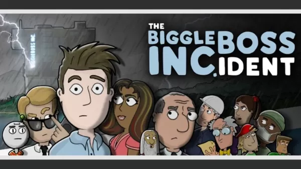 Point-and-Click Comedy Corporate Thriller The Biggleboss Incident Is Now Out on Android
BUNKWORKS has released its debut title for Android: The Biggleboss Incident, which previously arrived on Steam and iOS earlier this year. This narrative-driven point-and-click adventure unfolds within the confines of corporate life.A Humorous Yet Bri
Jun 02,2026 - ◇ MultiVersus Shuts Down, Players Mourn Beloved Game Jun 01,2026
- ◇ Alien Isolation Beginner's Guide – Survive the Xenomorph Horror Jun 01,2026
- ◇ Master Penguin GO! With 10 Expert Strategies May 30,2026
- ◇ Pokemon Sleep Update Boosts Appearance Rates, Candy Gains May 30,2026
- ◇ Undecember launches massive overhaul alongside 4th anniversary festivities May 28,2026
- ◇ Terra Nil Heatwave Update Adds Three New Maps May 28,2026
- ◇ Seven Knights ReBIRTH Equipment & Accessories Guide — Gear Up Your Heroes Smartly May 22,2026
- ◇ Clash Royale Returns with Retro Royale Mode May 20,2026
- ◇ "DELTARUNE Chapter 5 Launches in 2026" May 20,2026
- ◇ Pre-Order Skyrim Dragonborn Helmet Now at IGN Store May 20,2026
![Roblox Forsaken Characters Tier List [UPDATED] (2025)](https://img.actcv.com/uploads/18/17380116246797f3e8a8a39.jpg)

- 1 Silent Hill 2 Remake Confirms Xbox, Switch Release in 2025 Feb 08,2025
- 2 Fix 'Can't Connect to Host' Error in Ready or Not: Quick Solutions Jun 13,2025
- 3 The Best Free Comic Book Sites and Apps in 2025 Mar 18,2025
- 4 Dragon Soul Tier List: Ultimate Guide May 12,2025
- 5 Connect Asus ROG Ally to TV or Monitor: Easy Guide Apr 06,2025
- 6 "Persona Games and Spin-Offs: Complete Chronological List" Apr 09,2025
- 7 Assassin's Creed Shadows: Max Level and Rank Cap Revealed Mar 27,2025
- 8 How to Run JioHotstar on PC with BlueStacks Feb 28,2025


-
Top Arcade Classics and New Hits
A total of 10
-
Addictive Arcade Games for Mobile
A total of 10
-
Android Apps for Video Content Creation
A total of 10